
In the realm of space exploration, the visual documentation of our universe serves as the bridge between the technical rigors of aerospace engineering and the collective imagination of humanity. NASA has long held a "galactic lead" in this arena, consistently transforming complex missions into accessible, awe-inspiring narratives. In its latest effort to bring the cosmos closer to the public, the space agency has officially cataloged and released 12,217 high-resolution photographs captured during the Artemis II lunar flyby mission. These images, now available through the Gateway to Astronaut Photography of Earth, offer an unprecedented look at our celestial neighbor and our home planet from deep space.
The Magnitude of the Archive: A Visual Odyssey
The sheer scale of this release is staggering. Spanning over 12,000 individual frames, the collection represents a significant expansion of the existing Gateway to Astronaut Photography of Earth database—a repository that has served for years as the definitive archive for imagery captured by astronauts aboard the International Space Station (ISS). By integrating the Artemis II mission data, NASA has effectively bridged the gap between low-Earth orbit photography and deep-space lunar observation.
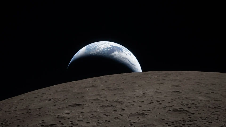
While a significant portion of the data set includes calibration frames, long exposures of the dark lunar surface, and star-field studies, the goldmine lies in the high-fidelity landscape shots. The images are of such extraordinary resolution that they transcend the needs of scientific study, proving suitable for large-scale digital displays and high-definition wall prints. Users can navigate through variations of Earthrises and Earthsets—phenomena that, while familiar to the Apollo-era generation, have never been documented with the clarity afforded by modern 21st-century optics.
Chronology of the Mission and Imaging Strategy
The Artemis II mission was not merely a flight test; it was a carefully choreographed exercise in public engagement and technical validation. The chronology of the imaging process began long before launch, with engineers meticulously selecting camera placements to ensure that every phase of the trajectory was documented.
- Launch and Initial Trans-Lunar Injection (TLI): The early phase of the mission focused on the hardware, documenting the separation of stages and the performance of the Orion spacecraft.
- The Lunar Flyby: As the crew approached the Moon, the focus shifted to topography. Using specialized long-lens configurations, the astronauts captured the lunar terminator—the elusive line separating day and night on the lunar surface. Because the Moon lacks an atmosphere, this line is rendered with a surgical sharpness that is impossible to replicate on Earth.
- The Return and Data Offloading: Upon the spacecraft’s return, the primary challenge shifted from capture to curation. Thousands of raw files required metadata tagging, color correction, and cataloging to ensure that they could be integrated into the existing NASA archives without corrupting the historical integrity of the data.
The mission’s success was further bolstered by the crew’s innovative use of personal-grade technology. In a historic first, members of the crew utilized their own smartphones to broadcast live updates from space, effectively democratizing the experience of space travel and setting a new precedent for how astronauts communicate with the public.
Supporting Data: Technical Specifications and Accessibility
The images are housed on the official Gateway to Astronaut Photography of Earth portal. For the layperson or the professional researcher, the platform provides a robust search interface that allows for filtering by mission, camera type, and orbital path.
- Resolution and Detail: The images utilize advanced sensor technology capable of capturing detail in the shadows of lunar craters, where light levels are exceptionally low.
- The Terminator Effect: Photogrammetry experts note that the images of the terminator line provide crucial data for future lunar landers. The contrast between the stark, illuminated peaks and the pitch-black craters serves as a vital navigational reference for autonomous landing systems.
- Data Volume: With over 12,000 files, the total size of the archive exceeds several terabytes of raw data. NASA has implemented a tiered download system, allowing users to select between compressed web-ready files and full-resolution TIFF files for professional publication.
Official Responses and Public Engagement
NASA officials have characterized this release as a vital component of the Artemis program’s mandate: to return humanity to the Moon while ensuring that the public remains a partner in the journey. "Our goal is not just to go back to the Moon, but to take everyone with us," a spokesperson for the Johnson Space Center stated during the launch of the image gallery.
The scientific community has lauded the decision to keep the data open-source. Unlike proprietary aerospace initiatives, NASA’s commitment to making these images public domain ensures that students, filmmakers, and amateur astronomers can utilize the material for educational and creative projects. This transparency is seen as a key strategic move to maintain public interest in the multibillion-dollar investments required for deep-space exploration.
Implications for Future Exploration
The release of these 12,217 images has profound implications for both science and the culture of space exploration.
1. Advancing Planetary Science
The detailed imagery of the lunar craters provides geologists with new perspectives on impact history. By studying the distribution of regolith and the erosion patterns visible in high-resolution, scientists can better predict the conditions that future Artemis III astronauts will encounter when they attempt to land at the lunar south pole.
2. Shifting Public Perception
We are entering an era where "space" is no longer an abstract concept relegated to grainy, black-and-white archives. By providing high-definition, high-contrast imagery, NASA is fostering a "planetary perspective." When the public can see the delicate blue marble of Earth set against the harsh, cratered backdrop of the Moon, the fragility of our own ecosystem becomes a more tangible reality.
3. Setting a Benchmark for Private Industry
As private companies like SpaceX and Blue Origin continue to expand their lunar ambitions, NASA has set a high bar for documentation. The Artemis II archive demonstrates that it is not enough to simply reach a destination; one must document it with a level of clarity that informs and inspires. The expectation for future commercial lunar flights will now inevitably include a high-fidelity visual component for the public.
Conclusion: A Window into the Beyond
The Gateway to Astronaut Photography of Earth is more than a digital library; it is a testament to human curiosity. As we look at the sun rising over the jagged, gray horizons of the Moon, or witness the delicate curve of our planet from 240,000 miles away, we are reminded of the distance we have traveled and the vastness that remains to be explored.
For those who wish to delve into this archive, the advice is simple: bring patience and a high-speed connection. The sheer volume of data is a reflection of a mission that sought to capture every shadow, every crater, and every glint of starlight. Whether you are a student looking for a desktop background or a scientist mapping the lunar surface, these 12,217 images offer a view of the universe that is, quite literally, out of this world. The Artemis II mission has successfully closed the loop between the Moon and the people of Earth, ensuring that while the spacecraft has returned home, the journey continues through the lenses of those who were there.


Leave a Reply