


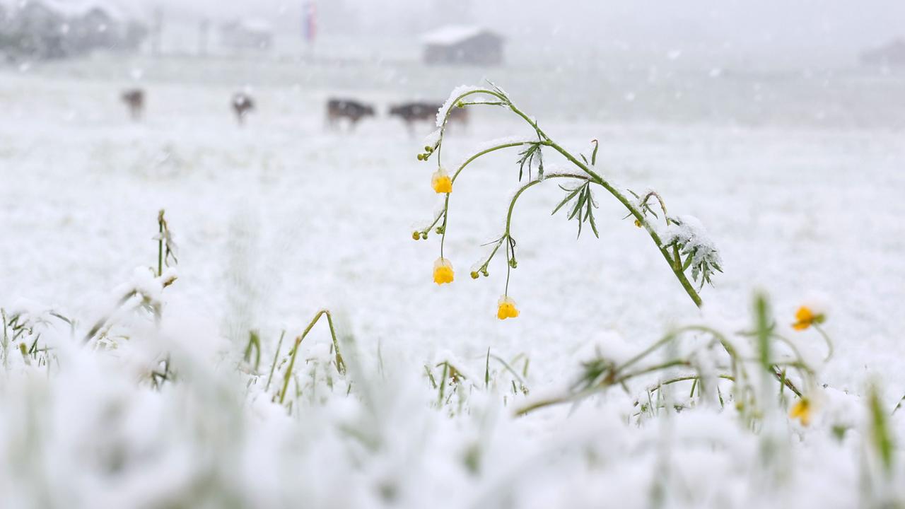
As temperatures plummeted across Germany this week, the promise of spring was temporarily buried under a blanket of white. From the peaks of the Alps to the ridges of the Harz Mountains, citizens awoke to a wintry scene that defied the typical expectations of mid-May.
The Sudden Shift: Main Facts and Current Conditions
In a sharp atmospheric reversal, parts of Germany have experienced a return to winter-like conditions, marked by significant snowfall and sub-zero temperatures in higher elevations. The phenomenon, which occurred precisely as the country entered the period traditionally known as the "Eisheiligen" (Ice Saints), saw landscapes in the Oberallgäu, the Brocken, the Fichtelberg, and the Black Forest transformed into scenes more characteristic of January than May.
While low-lying areas dealt with cold rain and biting winds, regions situated above 800 to 1,000 meters were subjected to accumulating snow, with some areas in the Allgäu Alps reporting upwards of 20 centimeters of fresh powder. This sudden cold snap follows a weekend of unseasonably warm weather, highlighting the volatile nature of mid-spring meteorology in Central Europe.
Chronology: A Countrywide Cold Snap
The meteorological transition began in the early hours of May 12, 2026. As a cold front moved in from the North Sea, bringing polar air masses deep into the German interior, the temperature gradient collapsed.
- Early Morning (May 12): Residents in the Oberallgäu region reported the first major accumulation of the day. Snowfall was heavy enough to necessitate the mobilization of local winter maintenance crews, and many residents were forced to clear driveways and vehicles before their morning commute.
- Mid-Morning: The cold front advanced eastward and northward. By 10:00 AM, the Brocken—the highest peak in the Harz Mountains—was reporting active snowfall accompanied by gusty winds and scattered thunderstorms, a rare combination for this time of year.
- Afternoon: The Fichtelberg in Saxony saw temperatures dip to minus 1 degree Celsius. The precipitation, initially rain, transitioned to snow, coating trees and infrastructure in rime ice and fresh snow. Simultaneously, webcams in the Black Forest captured the iconic Feldberg peak under a thick white mantle.
Supporting Data: Meteorological Context
The German Weather Service (DWD) has classified the event as a classic, albeit sharp, incursion of polar air. According to meteorologists, the descent of the snow line to 1,000 meters—and locally lower—is a consequence of a specific pressure configuration that funneled arctic air from the North Sea directly across the German landmass.
Elevation-Based Impacts
The DWD issued warnings for regions above 800 meters, citing the risk of "Schneematsch" (slushy snow) on roadways. While major traffic disruptions were largely avoided, the impact on local infrastructure was tangible:
- Allgäu: 5–10 cm of accumulation in standard elevated regions, with up to 20 cm in specific mountain basins.
- Erzgebirge: Temperatures dropped to -1°C, leading to hazardous ice formation on exposed surfaces.
- General Mid-Range Mountains: The Harz, the Eifel, and the Hochsauerland regions all reported light to moderate snow, enough to provide a visual reminder of the cold, even if the accumulation remained limited compared to the Alps.
Official Responses and Expert Analysis
Speaking on the timing of the event, a DWD spokesperson noted that while the intensity of the cold may feel shocking after a mild weekend, it remains within the realm of climatological probability for mid-May.
"It is typical that even in May, we see this influence of cold air masses," the DWD representative explained. "The timing happens to align perfectly with the traditional period of the ‘Ice Saints.’ This is a classic case of polar air penetrating deep into the mainland."
The DWD continues to monitor the situation, noting that while the current cold snap is transient, the danger of night frosts remains a primary concern for agricultural sectors across the country.
Implications: The Significance of the "Ice Saints"
The term "Eisheiligen" (Ice Saints) refers to the days of May 11 through May 15. In German folklore, these days are historically associated with the last significant frost of the year. The saints are Mamertus, Pancras, Servatius, Boniface, and finally, "Kalte Sophie" (Cold Sophia) on May 15.
Agricultural and Horticultural Impact
For the agricultural community, the arrival of the Ice Saints is not merely a piece of cultural history but a vital operational deadline.
- The Frost Risk: The primary concern during this window is the potential for night frosts. When the sky clears after a cold front, radiation cooling can cause temperatures to drop rapidly to near or below freezing, which is lethal for young, sensitive plants.
- Gardening Wisdom: It is a standard rule of thumb among professional gardeners and hobbyists alike that frost-sensitive plants—such as tomatoes, peppers, and various annual flowers—should not be planted in open ground until after the 15th of May.
- The "Cold Sophia" Threshold: The 15th is widely considered the threshold after which the risk of frost diminishes significantly. The current weather event serves as a stark reminder to those who may have planted their summer gardens prematurely during the previous weekend’s warmth.
A Fleeting Winter
Despite the dramatic imagery of snow-covered blossoms and white-capped mountain peaks, the forecast provides relief for those eager for spring. Meteorological models indicate that the cold spell will be short-lived. The polar air mass is expected to drift eastward, allowing for a gradual warming trend by mid-week.
By the end of the week, the "winter of May" will likely be relegated to social media photo archives and local news footnotes. The snow is expected to melt quickly as temperatures climb back toward seasonal averages, leaving behind only saturated soil and perhaps a lesson in patience for gardeners who were tempted by the false promise of an early summer.
Conclusion: Understanding Climate Volatility
The events of this week underscore the inherent volatility of spring weather in the temperate climate of Central Europe. While the "Ice Saints" are a well-documented phenomenon, the combination of high-pressure systems and the movement of polar air continue to create conditions that catch modern society off guard.
As the country moves past the 15th of May, the focus will shift from frost protection to irrigation and the growth cycles of late spring. The recent cold snap serves as a reminder of nature’s capacity to reset the seasonal clock, reinforcing the wisdom of long-standing agricultural traditions that prioritize caution over the early arrival of warmth. For now, the winter gear can be packed away once more, as the longer days of May prepare to reclaim the landscape from the clutches of the frost.






















Leave a Reply