


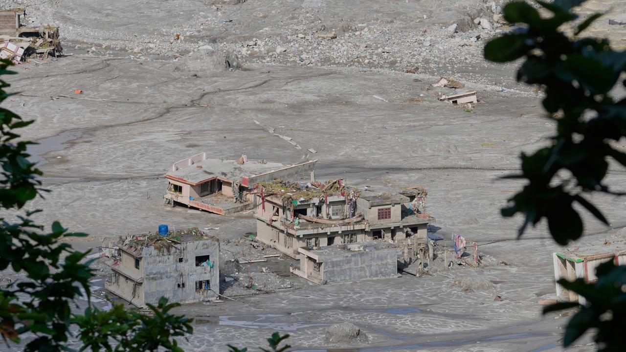
In the wake of a catastrophic rockslide and subsequent flash flood in Nepal, a groundbreaking study by World Weather Attribution (WWA) has peeled back the layers of a complex geological disaster. The findings suggest that the human-induced climate crisis played a far more decisive role in the destruction of the Langtang Lirung mountain range than initially estimated, revealing a dangerous hydrological mechanism that experts warn could soon pose a threat to the European Alps.
The Anatomy of a Disaster: Main Facts
For weeks following the collapse of the northern face of the 7,000-meter Langtang Lirung peak in Nepal, the scientific community struggled to reconcile the sheer scale of the resulting flash flood with the geological conditions of the region. While the Nepalese government had long pointed toward the accelerating climate crisis as the primary culprit, the specific chain of events remained obscured by technical uncertainty.
The WWA study, released on September 17, 2026, provides the definitive link between rising global temperatures and the mechanical failure of the mountain. It identifies a "perfect storm" of conditions: a geologically vulnerable slope, pre-weakened by the 2015 Gorkha earthquake, that was pushed past its breaking point by unprecedented thermal stress. The report confirms that the disaster was not merely an act of nature, but a direct consequence of a warming planet destabilizing the "eternal ice" of the high Himalayas.
A Chronology of Destabilization
To understand how such a massive geological feature could simply fail, researchers looked back at the decades leading up to the collapse.
- Pre-2015: The Langtang Lirung massif was already subject to the slow, creeping effects of global warming. The slope, while naturally steep, remained held together by permafrost—the "glue" of the high mountains.
- 2015: The massive earthquake that struck Nepal caused internal fractures within the rock face. While the mountain stood for several years afterward, these hidden fissures created pathways for water to penetrate the interior of the rock.
- The Pre-Collapse Years: Over the last decade, the region experienced a steady rise in temperatures. The "zero-degree line"—the altitude at which snow turns to liquid water—began to climb. Data shows this line rose by approximately 100 meters every ten years, shifting the thermal equilibrium of the mountainside.
- The Final Months: The 12-month period preceding the collapse was recorded as the warmest in the region’s history. The final two months were an extreme anomaly, causing record-breaking rates of glacial melt and the degradation of sub-surface permafrost.
- The Event: The massive volume of meltwater, unable to drain through frozen channels, pooled within the internal fractures of the rock. The resulting hydrostatic pressure effectively "jacked" the rock apart, leading to a catastrophic structural failure of the slope.
Supporting Data: The Fingerprints of Climate Change
The scientific data underpinning the WWA report is stark. Since the onset of the industrial era, the Himalayan region has seen temperatures climb by roughly 1.5 degrees Celsius. This is not a uniform warming; it is a rapid shift that has fundamentally altered the mountain’s hydrology.
The Rise of the Zero-Degree Line
The migration of the zero-degree line is perhaps the most significant indicator of systemic change. As this line creeps higher, regions that were historically locked in a deep-freeze are now subject to daily freeze-thaw cycles. This process is destructive to rock integrity; as water enters existing cracks during the day and expands upon freezing at night, it acts as a mechanical wedge, slowly prying the mountainside apart.
The Shift in Precipitation
The report highlights a critical change in how the Himalayas receive moisture. Increasingly, high-altitude regions are experiencing rain where snow used to fall. Unlike snow, which accumulates and contributes to a slow, controlled glacial build-up, rain is liquid and seeks immediate pathways downward. This water flows into glacial crevasses and, crucially, deep into the bedrock, where it exerts hydraulic pressure that can trigger landslides that would have been impossible in a colder climate.
Official Responses and Expert Analysis
The consensus among the international glaciological community is that our understanding of high-mountain hazards must undergo a paradigm shift.
Dr. Walter Immerzeel of Utrecht University, a lead author of the study, notes: "The slope was not just ‘old.’ It was destabilized by a complex interaction between glacial retreat, thawing permafrost, and an extraordinary volume of meltwater that had nowhere to go but into the rock itself."
Christoph Mayer of the Bavarian Academy of Sciences, who reviewed the findings, emphasizes the gravity of the situation. "We are witnessing a transition in these high-altitude zones," Mayer explains. "Areas that once maintained a stable, frozen state are now transitioning into states of perpetual thaw. This changes the structural geology of the entire range. We are seeing more water in the system than at any point in modern human history."
The Nepalese government, which had faced pressure to provide answers to affected mountain communities, has welcomed the study, noting that it provides the necessary scientific backing to advocate for international climate support and better disaster-preparedness infrastructure.
Implications: The Looming Threat to the Alps
Perhaps the most alarming takeaway from the WWA report is the realization that the Himalayan disaster is a "canary in the coal mine" for other mountainous regions, including the European Alps.
Monitoring the "Internal Water"
Historically, geological monitoring focused on surface-level changes—the movement of glaciers or the shifting of loose debris. The Langtang Lirung event has proven that the real danger often lies hidden within the rock. Future monitoring in the Alps will need to employ advanced geophysical techniques, such as electrical resistivity tomography, to detect water accumulation within bedrock before it causes a collapse.
Rethinking Hazard Zones
The findings suggest that existing hazard maps in the Alps may be outdated. If the mountain structure itself is being compromised by internal hydrostatic pressure, "safe" zones may no longer be safe. Authorities in Switzerland, Austria, and Italy are already under pressure to reassess the stability of high-altitude peaks that have long been considered "geologically dead" but are now experiencing accelerated thermal decay.
A Call for Global Action
The study concludes with a sobering reflection: the climate crisis is not just a threat to low-lying islands or agricultural belts; it is literally reshaping the topography of our planet’s highest peaks. The catastrophic event in Nepal serves as a violent reminder that when we change the climate, we change the physical stability of the ground beneath our feet.
As the world continues to grapple with the multifaceted impacts of global warming, the Himalayas stand as a silent, crumbling witness to the urgency of the moment. Without a significant reduction in greenhouse gas emissions and a massive investment in mountain-hazard monitoring, the tragedy of Langtang Lirung may be the first of many such events to reshape the map of the world’s great mountain ranges.
In the final assessment, the report concludes that while the geological vulnerability was a prerequisite, the climate change-driven thermal anomalies were the trigger. The disaster was an intersection of long-term climate trends and short-term weather extremes, a combination that is becoming increasingly frequent and increasingly lethal. For the scientists, the message is clear: the mountains are moving, and it is time for the world to pay closer attention to the warnings they are sending.