
By Editorial Staff
The state of Hessen finds itself in the grip of a volatile weather pattern this week, as residents across the region are waking up to scenes of wintry destruction in the middle of summer. Following a night of intense meteorological activity, emergency services are currently assessing the impact of localized, yet devastating, hailstorms that transformed residential streets into white, slushy landscapes.
As we kick off this Monday, the focus is squarely on damage mitigation, infrastructure assessment, and the broader implications of these increasingly frequent extreme weather events. This report provides a comprehensive look at the overnight chaos, the response from local authorities, and the mounting concerns regarding climate volatility in central Germany.
The Main Facts: A Summer Landscape Transformed
Late Sunday night, a high-intensity localized storm cell stalled over parts of the Lahn-Dill-Kreis region, specifically impacting communities such as Braunfels-Altenkirchen. Unlike typical summer thunderstorms that bring rain and wind, this system was characterized by its unusual thermal stratification, resulting in a heavy deposition of hail.
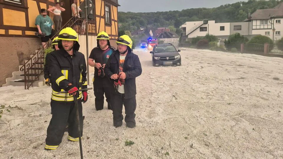
In some areas, the accumulation was so significant that municipal authorities were forced to deploy heavy machinery, typically reserved for winter snow removal, to clear the streets. The visual contrast was jarring: mid-July temperatures were momentarily forgotten as residents looked out upon lawns and roads blanketed in several inches of ice.
Key takeaways from the initial assessment include:
- Infrastructure Impact: Local roads were rendered impassable due to the density of the hail, which clogged drainage systems and created hazardous, slick conditions.
- Property Damage: While initial reports suggest no loss of life, significant damage has been recorded to residential rooftops, garden greenhouses, and personal vehicles.
- Agricultural Strain: Farmers in the surrounding rural belts are reporting extensive damage to crops, with many fields shredded by the sheer force of the hail impact.
Chronology of the Event: A Night of Unrest
The progression of the storm highlights the rapid development of convective weather systems that have become a hallmark of this year’s summer season.
Sunday Evening: The Calm Before the Storm
As of 8:00 PM on Sunday, the Deutscher Wetterdienst (DWD) had issued preliminary warnings for the region. While the initial forecast suggested moderate rain, the potential for "severe convective activity" was noted. In the Braunfels area, the air remained muggy and stagnant, with high humidity levels creating the perfect instability for a rapid updraft.
11:30 PM: The Onset
By midnight, the atmosphere destabilized rapidly. The storm cell, fueled by a collision of cold air from the upper atmosphere and the residual heat of the day, began to drop large-diameter hail. Within twenty minutes, the streets of Braunfels-Altenkirchen were coated in a white layer that defied the seasonal norms.
2:00 AM – 4:00 AM: The Emergency Response
Local volunteer fire departments were mobilized en masse. The primary concern during these early morning hours was not just the ice, but the potential for flooding as the ice began to partially melt, blocking storm drains. Emergency crews worked under floodlights to clear debris and monitor water levels in low-lying areas.
Monday Morning: The Assessment
As the sun rose over Hessen, the extent of the damage became clear. The fire department released imagery showing personnel wading through ankle-deep hail, an iconic image of the bizarre weather patterns currently challenging the region’s emergency infrastructure.
Supporting Data: Understanding the Meteorological Anomaly
Meteorologists are characterizing this event as a "supercell-lite" phenomenon. In such instances, the updraft within a thunderstorm is strong enough to keep ice pellets suspended in the atmosphere for an extended period, allowing them to grow in size and mass before gravity overcomes the updraft.
The Role of Atmospheric Instability
Data collected by regional weather stations indicates that the dew point in the Lahn-Dill-Kreis was significantly elevated throughout the weekend. This provided the "fuel" for the storm. When this air mass encountered a cold front moving in from the northwest, the resulting collision was violent.
Frequency and Intensity Trends
According to historical data from the Hessian State Agency for Nature Conservation, Environment and Geology (HLNUG), the frequency of extreme weather events—defined as storms producing hail larger than 2 centimeters or heavy precipitation exceeding 30mm per hour—has seen a marked increase over the last decade. While no single event can be attributed solely to long-term climate change, the trend lines suggest that the "new normal" for Hessen includes a higher probability of these high-impact, low-duration atmospheric events.
Official Responses: Coordination and Resilience
The response to the storm has been swift, with municipal leaders praising the volunteer fire departments for their rapid mobilization.
"The speed at which the landscape changed was unprecedented," noted a spokesperson for the Braunfels fire department. "Our priority throughout the night was to ensure that emergency corridors remained open. We are now shifting our focus to assisting residents with property damage assessments."
Government Support
The Hessian Ministry of the Interior has confirmed that it is monitoring the situation. While current damage estimates remain below the threshold for a state-level disaster declaration, local municipalities are being encouraged to document all costs associated with the cleanup to potentially access regional emergency relief funds.
Insurance providers are also bracing for an influx of claims. In Germany, "elemental damage" insurance—which covers hail and flooding—is not mandatory for all homeowners. Consequently, there is growing concern that many residents may be facing significant out-of-pocket expenses for roof repairs and vehicle bodywork.
Implications: The Long-Term Challenges for Hessen
The aftermath of this hailstorm serves as a microcosm of the challenges facing Central Europe. As urban areas grow and infrastructure ages, the capacity of drainage systems to handle sudden influxes of water and ice becomes a critical issue.
Urban Planning and Infrastructure
Urban planners are increasingly looking at "sponge city" concepts—designing infrastructure that can absorb excess water and manage extreme temperature swings. The fact that a summer hail event can paralyze a town for several hours suggests that current infrastructure is tuned for a climate that no longer exists.
Economic Impact on Agriculture
For the agricultural sector, the timing of the storm is particularly brutal. Coming in the middle of the growing season, the destruction of crops represents a significant loss of income for local farmers. Discussions are already underway regarding the necessity of modernizing agricultural insurance schemes to protect against increasingly unpredictable weather.
The Public Sentiment
There is a palpable sense of anxiety among the population. Social media channels in Hessen have been flooded with photos and videos of the event, with many users expressing shock at the intensity of the storm. This "weather anxiety" is becoming a factor in local politics, with citizens increasingly demanding that local governments prioritize climate adaptation strategies.
Conclusion: Looking Ahead
As the cleanup continues throughout Monday, the residents of Braunfels-Altenkirchen are a testament to the resilience of the Hessian spirit. However, the event serves as a stark reminder that the environment is becoming less predictable.
The DWD has warned that while the current system is moving out of the region, the atmosphere remains unstable. Further thunderstorms are possible later in the week, and emergency services are remaining on high alert. For now, the people of Hessen are left to sweep away the remnants of a summer night that felt more like mid-winter—a chilling reminder of the volatility inherent in our changing climate.
We will continue to update this live ticker throughout the day as more information becomes available regarding damage estimates and recovery efforts. Please remain cautious, avoid traveling through flooded or ice-covered underpasses, and monitor official channels for further weather alerts.