


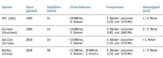
In the modern age, Global Navigation Satellite Systems (GNSS)—the umbrella term for GPS, Galileo, GLONASS, and BeiDou—are the invisible backbone of the global economy. From timing the high-frequency trades on Wall Street to ensuring the precise flight paths of commercial airliners and the automated navigation of cargo ships, our world relies on signals beamed from orbit. However, this critical infrastructure is currently under siege.
Increasingly, pilots, mariners, and logistics operators are reporting widespread interference with satellite navigation. What was once a niche concern for military strategists has evolved into a daily reality for civilian aviation and maritime transport, particularly in regions defined by geopolitical tension.
The Nature of the Threat: Jamming vs. Spoofing
The interference manifesting in the skies over the Baltic Sea, the Middle East, and parts of the Indo-Pacific is not merely a technical glitch; it is a manifestation of modern "hybrid warfare." Security analysts note a shift in the sophistication of these attacks.

Jamming: The Brute Force Approach
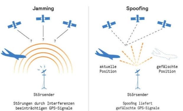
Jamming is the most straightforward form of interference. It involves flooding the frequency bands used by GNSS satellites with high-power, broadband noise. Think of it as a sonic "white noise" machine that drowns out the weak signals arriving from space. When a receiver is jammed, it loses its ability to calculate a position, effectively "blinding" the navigation system.
Spoofing: The Deceptive Deception
Far more dangerous is "spoofing." Unlike jamming, which simply denies service, spoofing is an act of digital mimicry. An attacker transmits a signal that mimics the authentic satellite data but contains false coordinates or timing information. If the receiver "locks onto" the fake signal, the vehicle’s navigation computer can be tricked into believing it is miles away from its actual location. This can lead to catastrophic results, such as aircraft being diverted into restricted airspace or ships being nudged off-course in crowded waterways.
Chronology of a Growing Crisis
The escalation of GNSS interference has been a slow-burn phenomenon that reached a boiling point in the mid-2020s.

- 2022-2023: Initial reports of GPS interference begin to surface near conflict zones, primarily attributed to regional military operations testing electronic warfare capabilities.
- Late 2024: A significant increase in "spoofing" events is recorded by commercial airlines over the Baltic and Black Seas. Regulatory bodies begin issuing warnings to pilots regarding "unreliable navigation data."
- Summer 2026: A landmark study from Poland reveals that, at certain times, satellite navigation availability in the Baltic Sea plummeted to as low as 83 percent. The industry begins to acknowledge this as a systemic vulnerability rather than a series of isolated incidents.
- September 2026: MIT Technology Review publishes a comprehensive analysis highlighting that the reliance on a single, vulnerable technology—GNSS—has become a structural weakness in global logistics and security.
Supporting Data: Mapping the Invisible Battlefield
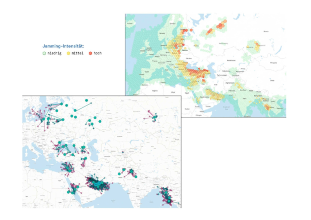
Data aggregated by organizations such as GPSwise and Orbital Radar paints a sobering picture of a world where navigation signals are no longer reliable.
Regional Hotspots
- Eastern Europe: The Baltic region currently serves as the epicenter of jamming activity. Analysts point to the proliferation of ground-based electronic warfare assets as the primary culprit.
- The Middle East and Persian Gulf: These regions experience both high levels of jamming and consistent, sophisticated spoofing, often linked to ongoing regional power struggles.
- The Red Sea and Indo-Pakistani Border: These areas show a unique concentration of spoofing, where the manipulation of navigation data is used as a tactical tool to disrupt maritime and aerial corridors.
The correlation between these zones of interference and active geopolitical conflict suggests that satellite signal manipulation has become a standard, low-cost "nudge" in the playbook of modern state-sponsored hybrid warfare. Because the signals are cheap to generate and the impact is widespread, they provide an ideal method for disrupting an adversary without crossing the threshold of conventional kinetic warfare.
Official Responses and Industry Vigilance
The aviation and maritime industries are scrambling to adapt. The International Civil Aviation Organization (ICAO) and the International Maritime Organization (IMO) have both ramped up their guidance, urging operators to rely more heavily on "dead reckoning" and terrestrial-based navigation aids that were largely sidelined during the GPS boom.
The Problem of Global Over-Reliance
Governments are now facing a difficult realization: we have over-optimized our world for GPS. By making GPS the primary source of truth for everything from banking timestamps to autonomous logistics, we have created a single point of failure.
"The vulnerability is inherent in the design," notes one cybersecurity expert. "GNSS signals are weak because they travel thousands of kilometers from space. Any signal that is weak can be mimicked or suppressed with enough power. We have been living in a golden age of signal reliability that is now coming to an end."
Implications: The Search for Alternatives
As the reality of a contested signal environment sets in, engineers are looking toward a future where navigation is "multi-modal" and resilient.
1. Enhanced Terrestrial Navigation
Before GPS, navigation relied on terrestrial beacons (like VORs for aircraft or LORAN for ships). These are harder to spoof globally because they are localized. There is now a push to revitalize or modernize these ground-based systems as a fallback.
2. Inertial Navigation Systems (INS)
Modern INS technology, using high-precision gyroscopes and accelerometers, has become significantly cheaper and more accurate. By measuring movement relative to a known starting point, an INS can maintain a position fix without external signals for hours or even days. The goal is to integrate INS so tightly with GPS that the system automatically rejects any signal that deviates from the physical laws of motion.
3. Vision-Based Navigation (VBN)
Newer autonomous systems are being equipped with cameras and AI that "see" the terrain below them. By matching visual landmarks (mountains, coastlines, city grids) against high-resolution satellite imagery, a vehicle can determine its location entirely independent of satellite signals.
4. Quantum Sensors
In the long term, researchers are looking at quantum accelerometers. These sensors, which track subatomic particles to measure movement, offer extreme levels of precision that could render external signals unnecessary for long-haul navigation.
Conclusion: A New Era of Navigation
The era of trusting a single, unprotected digital signal from space is drawing to a close. As global powers continue to test the boundaries of electronic warfare, the private sector must prepare for a future where the sky is not always a reliable guide.
Whether through the hardening of receivers to distinguish between authentic and spoofed signals, or the return to traditional navigation methods supported by advanced AI and inertial sensors, the industry must pivot. Resilience, rather than mere convenience, must become the hallmark of our navigation infrastructure.
As we look toward the end of the 2020s, the lesson is clear: in an increasingly connected and competitive world, the most critical technology is the one that works when everything else fails. The invisible war above is not going away; it is merely becoming the new baseline for global navigation.