
In a significant technological leap for municipal emergency management, the city of Wiesbaden has launched a pioneering pilot project that promises to change the "first look" at disaster scenes. By integrating autonomous drone technology directly into the dispatch process, the Wiesbaden Fire Department aims to bridge the critical information gap that exists between the moment an alarm sounds and the moment the first fire engine arrives at the scene.
Main Facts: A Paradigm Shift in Emergency Response
The core of the initiative is simple yet revolutionary: as soon as the emergency alarm is triggered at the dispatch center, a specialized drone is deployed automatically. Within less than 30 seconds, the unmanned aerial vehicle (UAV) is airborne, charting a pre-calculated route to the coordinates of the incident.
Flying at an altitude of 100 to 120 meters, the drone utilizes advanced onboard sensors to navigate toward the emergency site, avoiding obstacles and aerial hazards autonomously. Once on-scene, the drone descends to a hovering altitude of 30 meters, providing high-definition live video feeds to both the Integrated Control Center and the command vehicles already en route. This allows incident commanders to assess the scale of a fire, the number of vehicles involved in a collision, or the spread of a chemical spill before they even set foot on the ground.
Chronology of the Initiative
The journey toward this high-tech integration has been a methodical process of testing and collaboration.
- Early 2025: The project draws inspiration from successful deployments in Munich, which became the first major German urban center to integrate automated drone scouting into its fire department operations.
- Mid-2026: Following extensive planning, Wiesbaden formally announced its partnership with Skyflow, a Berlin-based firm specializing in drone network infrastructure.
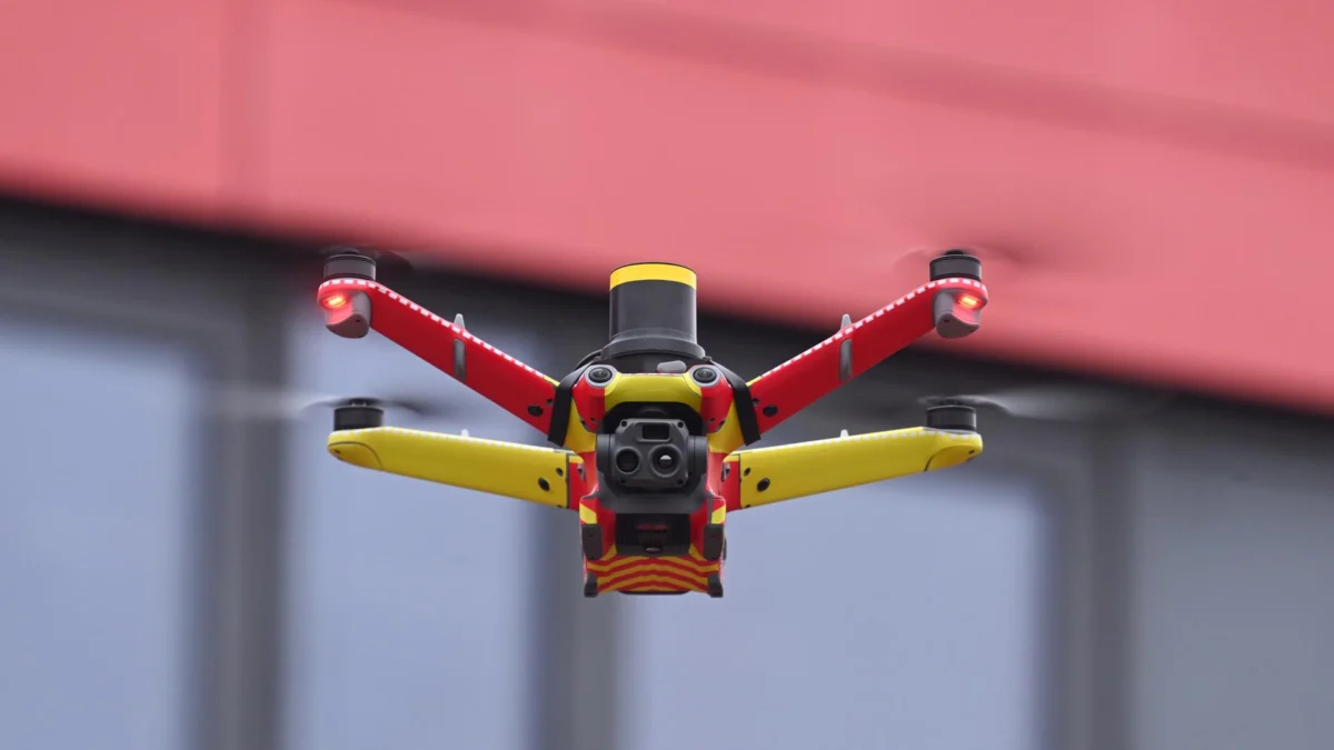
- The Pilot Phase (Upcoming Months): The hardware, a compact, high-visibility red-and-yellow drone, will be permanently stationed on the roof of the fire station in Igstadt—a district characterized by its mix of rural landscapes and suburban density. This location was chosen specifically to test the drone’s capabilities in diverse terrain, from forested outskirts to densely populated residential areas.
Technical Specifications and Operational Workflow
The "first responder" drone is more than a simple remote-controlled toy. It is a sophisticated piece of industrial equipment designed for rapid deployment and reliability.
The Deployment Sequence
When a call enters the Integrated Leitstelle (Dispatch Center), the system does not wait for a human pilot to arrive at the scene. Instead, the dispatchers initiate the automated sequence. The drone exits its weather-hardened docking station on the Igstadt roof, performs a self-diagnostic check, and ascends.
Navigation and Safety
The drone operates using a pre-calculated flight path, but it is not "blind." Equipped with LiDAR and optical obstacle-avoidance sensors, the craft can detect power lines, tall trees, or other aerial obstacles. Crucially, while the flight is automated, a human pilot maintains "over-the-shoulder" supervision, providing final clearance and monitoring the flight path for unforeseen developments.
Real-Time Data Streaming
The primary value of this system is the intelligence it feeds back to command staff. By the time a fire engine has navigated through city traffic, the fire chief already has a bird’s-eye view of the intensity of the blaze, the wind direction, and potential rescue routes. This data is transmitted in real-time, effectively eliminating the "fog of war" that often hampers the first few minutes of an emergency operation.
Supporting Data and Comparative Analysis
While drones have been used by fire departments in Germany for years, they have historically been "on-demand" assets. Typically, a specialist unit must be dispatched with the drone, which then takes several minutes to set up and launch.
Wiesbaden’s project is distinct because of its proactive nature. According to the Hessian Ministry of the Interior, while drone usage is growing across the state, this is the first project of its kind in Hesse to utilize a permanently stationed, automatically deployed drone for pre-arrival reconnaissance.
The benchmark for this success is the Munich model, which reported significant improvements in tactical planning since its 2025 rollout. By reducing the time-to-intelligence, departments in Munich found they could better allocate resources—such as deciding whether to send additional ladder trucks or hazardous materials units—before the first responders even arrived. This efficiency is expected to be mirrored, if not improved upon, in Wiesbaden’s diverse operational environment.
Official Responses and Strategic Implications
The city of Wiesbaden views this project as a cornerstone of modernizing public safety. "The goal is to provide our emergency services with the most accurate information possible in the shortest amount of time," a city spokesperson stated. By leveraging the expertise of Skyflow, the city is betting that software-driven automation will lead to faster response times and safer outcomes for both victims and firefighters.
Tactical Benefits for Firefighters
For the firefighters themselves, the drone serves as a critical safety tool. Knowing the layout of a building or the severity of a chemical leak before entering the "hot zone" allows for more informed risk assessments. It prevents unnecessary exposure to hazards and allows commanders to deploy personnel to the most critical sectors of an incident immediately upon arrival.
Privacy and Regulatory Considerations
The use of drones in public spaces naturally raises questions regarding data privacy and surveillance. City officials have been quick to emphasize that the drone’s purpose is strictly operational. The live feeds are intended for situational awareness during an active emergency, and protocols are in place to ensure that data collection is limited to the scope of the incident. The drone is not a surveillance tool for general policing; it is a tactical tool for life-saving operations.
The Future of "Smart" Firefighting
The implications of this pilot project extend far beyond Wiesbaden. If successful, the Igstadt model could serve as a blueprint for other medium-sized German cities and rural districts that lack the resources for massive, full-time drone teams but still require high-level reconnaissance capabilities.
Challenges Ahead
The project is not without its hurdles. Integrating autonomous flight paths into the existing airspace—often crowded by rescue helicopters, news drones, and civilian air traffic—requires stringent coordination with aviation authorities. Furthermore, the reliability of the docking and launching mechanisms in harsh weather conditions (such as heavy rain or freezing temperatures) will be a key metric during the evaluation phase.
A New Standard of Care
As urbanization continues and traffic congestion complicates the rapid deployment of emergency vehicles, the "eyes in the sky" approach will likely become an industry standard. Wiesbaden is at the forefront of this shift, demonstrating that the future of firefighting is not just about faster trucks, but about smarter, data-driven intelligence.
As the residents of Igstadt look up to see the red-and-yellow drone taking flight, they are witnessing a transformation in public safety—a transition from reactive firefighting to proactive, informed emergency management. The data gathered over the coming months in this pilot will likely dictate the future of municipal emergency response across Germany for the next decade. If the project proves successful, the image of a fire station will no longer be defined solely by its heavy engines, but also by the autonomous sentinels waiting on its roof, ready to provide clarity in the midst of chaos.