

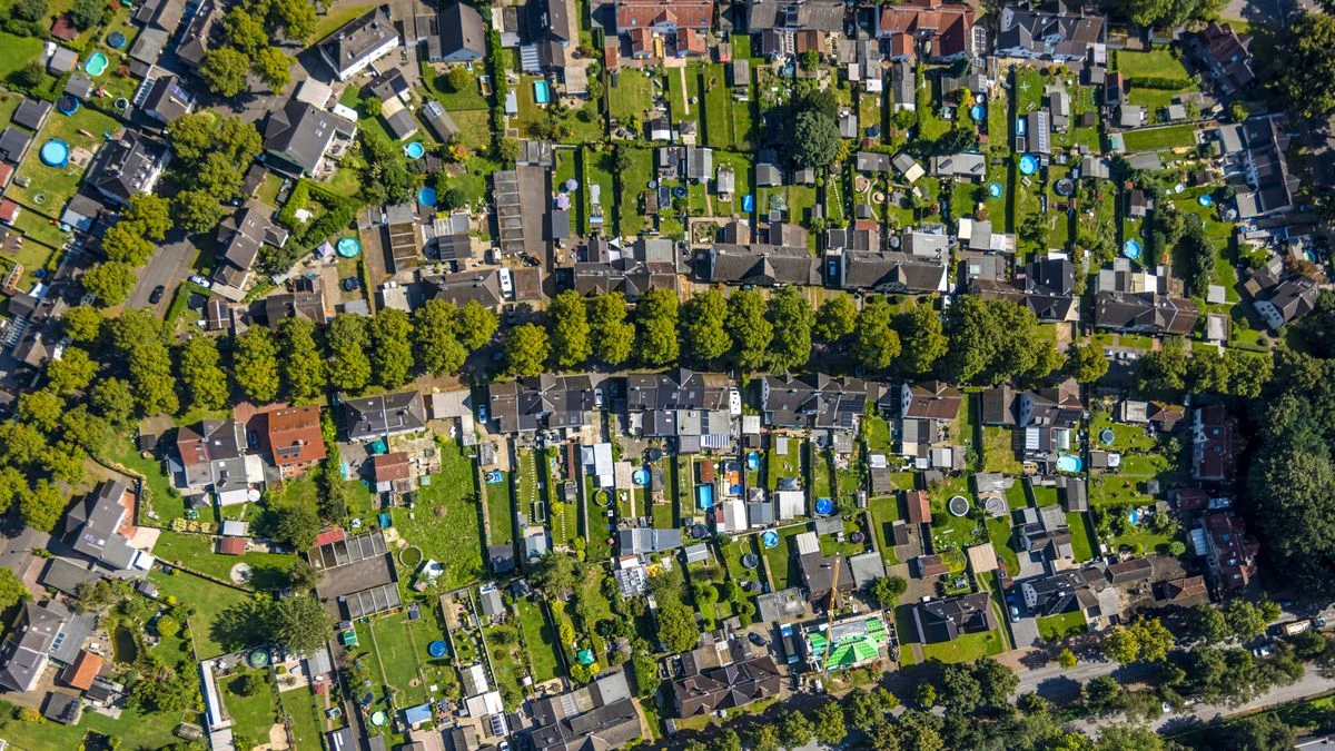
In a legal development that could reshape the boundaries of digital privacy in the 21st century, a court in Frankfurt am Main has issued a landmark ruling against tech giant Google. The case centers on a private homeowner who successfully challenged the company’s right to display high-resolution satellite and aerial imagery of his residential property on the platforms Google Maps and Google Earth.
The ruling, which underscores the escalating tension between technological progress and the fundamental right to privacy, establishes a potentially precedent-setting legal stance: individuals are not obligated to accept the worldwide, non-consensual publication of their private, non-visible property grounds. While the decision is not yet final, it serves as a significant warning to data-driven corporations that the "Abenteuergeist" (spirit of adventure) of digital mapping does not grant an absolute license to bypass personal protection rights.
The Core Facts: A Victory for Homeowner Privacy
The dispute involved a Frankfurt-based father who, having already forced Google to blur his home’s facade in the "Street View" function, turned his attention to the bird’s-eye view. The claimant argued that while street-level imagery might be considered public record, the high-altitude, detailed aerial photography provided by Google Maps and Google Earth went a step further, exposing parts of his property that were entirely shielded from public view—such as backyards, terraces, and private recreational areas.
The regional court’s Pressekammer (press chamber) sided with the plaintiff, emphasizing that the lack of consent was the critical failing. The ruling (Aktenzeichen: 2-03 O 388/25) declared: "No one must accept that aerial photographs of their inhabited property are distributed publicly worldwide without their consent, at least when parts of the property are depicted that are shielded from public view."
Chronology of the Legal Battle
The journey to this verdict did not happen overnight. It represents the culmination of a multi-year effort by the plaintiff to regain control over his digital footprint:
- Initial Action (Street View): Years prior to the recent satellite ruling, the plaintiff successfully navigated Google’s established grievance procedure to have his home obscured in Street View. At that time, such protections were becoming common as homeowners across Europe pushed back against the invasive nature of camera-equipped vehicles.
- Expansion of Concern: As technology advanced, the detail available in "Satellite View" increased significantly. The plaintiff noted that he had no mechanism to protect his rear garden or internal property layout from the high-resolution images provided via satellite and aerial flyovers.
- Filing the Lawsuit: The homeowner initiated formal proceedings in Frankfurt, arguing that the constant availability of these images constituted an intrusion into his private life.
- The Court Decision (October 20, 2026): The regional court issued its ruling, siding with the homeowner and explicitly rejecting the idea that Google’s interest in global mapping supersedes an individual’s right to seclusion.
- Current Status: The judgment is currently non-final, as Google maintains the right to appeal to the Higher Regional Court (Oberlandesgericht) of Frankfurt.
The Mechanics of the "Global Eye"
To understand the scope of the ruling, one must understand how Google creates its maps. The "Satellite" view on Google Maps is rarely a live feed from a single orbiting satellite. Instead, it is a mosaic of high-resolution imagery captured by various commercial providers, often using aircraft flying at lower altitudes than satellites to achieve greater clarity.

These images are processed, stitched together, and occasionally rendered in three-dimensional formats, allowing users to "zoom in" on private dwellings from almost any angle. The court noted that these images are collected clandestinely—without prior warning or the ability for a homeowner to cover their private areas before the flight takes place. This lack of agency, the court noted, is a form of "spying" that the average citizen cannot reasonably be expected to tolerate.
Official Responses and the "Abenteuergeist" Argument
During the proceedings, Google defended its practices by framing them as essential to the modern digital infrastructure. The company argued that its mapping services serve a legitimate public interest, promoting the "democratization of knowledge" and contributing to a transparent information society.
The court acknowledged these goals but engaged in a rigorous "interest-balancing" test. The judges conceded that Google successfully satisfies the human "spirit of adventure"—the desire to explore the world digitally. However, the court concluded that this purpose, while legitimate, is not sufficient to outweigh the constitutional protections of a private property owner.
The ruling highlighted a chilling implication of these images: that they provide granular data that could be exploited by third parties to monitor the lives of residents or even to facilitate criminal activities, such as planning a burglary. By exposing the layout of private homes, the court argued that the service inadvertently provides a toolkit for those who wish to invade the privacy and security of others.
Broader Implications: What Does This Mean for the Future?
This ruling sends a seismic shock through the tech industry, which has long operated under the assumption that images taken from "public airspace" are fair game. If the decision is upheld, it could force a massive operational shift for companies like Google, Apple, and various mapping services.
1. The End of the "One-Size-Fits-All" Mapping Model
Currently, Google Maps allows users to request the blurring of their property in Street View via a "Report a Problem" link. However, there is no such automated mechanism for aerial or satellite imagery. This ruling suggests that tech companies will be legally compelled to develop similar, robust removal or blurring request processes for satellite data, potentially costing millions in image processing and legal compliance.

2. The Definition of "Public Space"
The legal definition of what is "public" is shifting. Traditionally, anything visible from the sky was considered fair game. This ruling asserts that there is a distinction between the "public sphere" (the street) and the "private sphere" (the backyard). Courts are increasingly viewing privacy as a dynamic concept that evolves alongside the technology that threatens it.
3. A Precedent for EU Privacy Law
Given the European Union’s strict stance on data privacy—exemplified by the GDPR—this German court ruling could influence similar legal challenges across the continent. Should this case reach the European Court of Justice (ECJ), it could solidify a continent-wide right for citizens to "opt-out" of aerial surveillance by commercial mapping giants.
4. Security Concerns
The court’s explicit mention of the use of these images for planning "burglaries" reflects a growing awareness of the intersection between digital data and physical safety. In an era where "open-source intelligence" (OSINT) is becoming more accessible, the court’s willingness to prioritize security over public information may set a tone for future regulations regarding how much detail mapping services are allowed to share.
How Homeowners Can Currently Protect Themselves
While the legal battle continues, the current reality for homeowners remains complex. Those wishing to protect their privacy must navigate the limited tools provided:
- Street View: Users can go to the Street View interface, click "Report a Problem," and select the option to blur their home. This process is generally well-established and accepted by Google.
- The Satellite Gap: As of today, there is no equivalent "Report a Problem" feature for satellite or aerial imagery. The Frankfurt ruling suggests this is a significant legal oversight that tech companies will eventually be forced to address.
- Monitoring: While there is no way to prevent an overflight, homeowners can monitor Google’s "Street View" project page to see if camera vehicles are operating in their area. However, these lists are broad and often lack the precision required for proactive privacy management.
Conclusion
The Frankfurt court’s decision is more than a local dispute over a single property; it is a declaration that the digital age cannot be built upon the erosion of the private home. By challenging the "Abenteuergeist" of Google’s mapping empire, the court has placed a stake in the ground, asserting that the right to one’s own sanctuary—even from the perspective of the sky—remains a fundamental liberty.
As the case moves to the higher courts, the tech industry will be watching closely. Whether Google chooses to appeal, modify its imagery, or develop new privacy-focused tools will determine the next chapter in the fight for digital sovereignty. For now, one Frankfurt homeowner has proven that even in the age of global, high-resolution surveillance, the individual still has a voice—and that voice carries the weight of the law.